
Identity area
Reference code
BR MTAPMT RFP-MAP-1053
Title
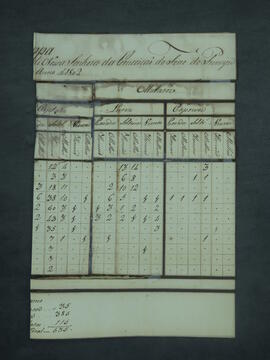
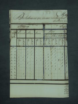
MAPA DE POPULAÇÃO do Real Forte Príncipe da Beira do ano de 1802.
Date(s)
- 1802, [...], [...] (Creation)
Level of description
Dossiê / Processo
Extent and medium
03 folhas
Context area
Name of creator
Repository
Archival history
Immediate source of acquisition or transfer
Content and structure area
Scope and content
Appraisal, destruction and scheduling
Accruals
System of arrangement
Conditions of access and use area
Conditions governing access
Conditions governing reproduction
Language of material
Script of material
Language and script notes
Physical characteristics and technical requirements
Manusear com cuidado
Finding aids
Allied materials area
Existence and location of originals
Existence and location of copies
Related units of description
Notes area
Alternative identifier(s)
Access points
Subject access points
Place access points
Name access points
Genre access points
Description control area
Description identifier
Institution identifier
Rules and/or conventions used
Status
Level of detail
Dates of creation revision deletion
Language(s)
Script(s)
Sources
Referência Anterior: S/Nº Fundo: Governadoria Lata: 1802 B